|
|
| (34 dazwischenliegende Versionen von 4 Benutzern werden nicht angezeigt) |
| Zeile 1: |
Zeile 1: |
| <html>
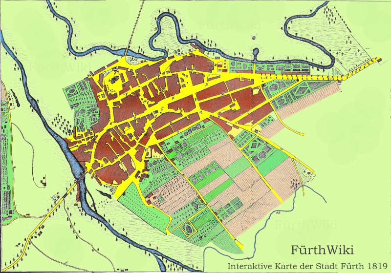
| | Diese interaktive Karte stellt die Stadt Fürth im Jahr [[1819]] dar. Grundlage ist die Skizze aus [[Johann Gottfried Eger]]s [[Taschen- und Adress- Handbuch von Fürth im Königreiche Baiern (Buch)|Stadtchronik]] aus eben diesem Jahr. Koloriert und digitalisiert 2008 durch das FürthWiki-Team. |
| <body>
| |
| <div id="interakka" style=" background-attachment:scroll; background-color:#51AB4F; background-image:url(fue_wappen.jpg); background-position:5px 0; background-repeat:no-repeat; height:24px;
| |
| padding: 2px; border: 1px solid #AAAAAA; text-align:left; padding-left:38px; width:760px;">'''FürthWiki: Interaktive Karte der Stadt Fürth von 1819'''</div><div id="layer" style="width:800px; height:559px;"><img src="http://fuerthwiki.de/Fuerth_1819k.jpg" width="800" height="559" border="0" alt="Karte" usemap="#Landkarte">
| |
| <map name="Landkarte">
| |
| <area shape="circle" coords="234,162,10"
| |
| href="http://fuerthwiki.de/wiki/index.php/Kirche_St._Michael" alt="Kirche St. Michael" title="Kirche St. Michael">
| |
| <area shape="poly" coords="244,152,248,150,255,166,250,169,244,152")
| |
| href="http://fuerthwiki.de/wiki/index.php/Pfarrhaus_St._Michael" alt="Pfarrhaus St. Michael" title="Pfarrhaus St. Michael">
| |
|
| |
|
| <area shape="poly" coords="211,264,234,251,231,231,225,231,222,249,211,264")
| | Einfach mit dem Mauszeiger über die einzelnen Stellen der Karte fahren, an aktiven Stellen erscheint ein Text - per Klick gelangt man zum entsprechenden Artikel im FürthWiki. |
| href="http://fuerthwiki.de/wiki/index.php/Marktplatz" alt="Marktplatz" title="Marktplatz (Grüner Markt)">
| |
| <area shape="poly" coords="184,330,192,322,198,293,209,276,217,267,210,263,195,287,187,310,184,330")
| |
| href="http://fuerthwiki.de/wiki/index.php/Königstraße" alt="Untere Frankfurter Strasse" title="Untere Frankfurter Str. (Untere Köngistr.)">
| |
| <area shape="poly" coords="241,257,298,236,294,231,239,250,241,257")
| |
| href="http://fuerthwiki.de/wiki/index.php/Königstraße" alt="Roßengasse" title="Roßengasse (heute Teil der Königstr.)">
| |
| <area shape="poly" coords="303,299,318,295,336,318,326,323,296,322,303,299")
| |
| href="http://fuerthwiki.de/wiki/index.php/Fraveliershof" alt="Fraveliershof" title="Fraveliershof">
| |
| <area shape="poly" coords="231,204,329,150,331,155,232,209,231,204")
| |
| href="http://fuerthwiki.de/wiki/index.php/Gustavstraße" alt="Bauerngasse" title="Bauerngasse (heute Gustavstraße)">
| |
| <area shape="poly" coords="260,274,266,272,271,279,265,284,260,274")
| |
| href="http://fuerthwiki.de/wiki/index.php/Synagoge" alt="Synagoge" title="Jüdische Synagoge">
| |
| <area shape="poly" coords="428,424,434,420,442,431,484,402,496,420,452,454,428,424")
| |
| href="http://fuerthwiki.de/wiki/index.php/Lochnersches_Gartenhaus" alt="Pfarrgarten" title="Lochnerscher Pfarrgarten">
| |
| <area shape="poly" coords="320,295,323,293,347,326,386,370,408,393,427,424,490,496,483,499,402,391,319,295,320,295")
| |
| href="http://fuerthwiki.de/wiki/index.php/Theaterstraße" alt="Theaterstrasse" title="Fußweg nach Dambach (heute Theaterstraße)">
| |
| <area shape="poly" coords="411,552,415,508,433,501,492,525,511,509,519,470,563,425,613,377,681,398,657,433,514,555,411,552")
| |
| href="http://fuerthwiki.de/wiki/index.php/Landgraben" alt="Landgraben" title="Landgraben">
| |
|
| |
|
| <area shape="poly" coords="471,192,492,184,503,213,486,224,471,192")
| | {{#widget:Karte 1819}} |
| href="http://fuerthwiki.de/wiki/index.php/Brauerei_Lederer" alt="Brauerei Lederer" title="Brauerei Lederer (spätere Brauerei Geismann)">
| |
| <area shape="poly" coords="503,176,518,171,518,161,494,158,503,176")
| |
| href="http://fuerthwiki.de/wiki/index.php/Brauerei_Mailänder" alt="Brauerei Mailaender" title="Brauerei Mailänder">
| |
| <area shape="poly" coords="505,180,514,177,514,181,530,176,540,197,518,208,505,180")
| |
| href="http://fuerthwiki.de/wiki/index.php/Brauerei_Humbser" alt="Brauerei Humbser" title="Brauerei Humbser">
| |
| <area shape="poly" coords="251,117,257,121,298,1,290,1,251,117")
| |
| href="http://fuerthwiki.de/wiki/index.php/Ludwigsbrücke" alt="Poppenreuther Bruecke" title="Poppenreuther Brücke (heute Ludwigsbrücke)">
| |
| <area shape="poly" coords="401,226,410,223,432,232,411,248,401,226")
| |
| href="http://fuerthwiki.de/wiki/index.php/Kohlenmarkt" alt="Kohlenmarkt" title="Kohlenmarkt">
| |
| <area shape="poly" coords="429,235,512,270,515,260,435,231,429,235")
| |
| href="http://fuerthwiki.de/wiki/index.php/Schwabacher_Straße" alt="Schwabacher Strasse" title="Schwabacher Straße">
| |
| <area shape="poly" coords="154,373,176,347,179,352,156,377,154,373")
| |
| href="http://fuerthwiki.de/wiki/index.php/Maxbrücke" alt="Untere Bruecke" title="Untere Brücke (heute Maxbrücke)">
| |
| <area shape="poly" coords="155,411,164,410,161,374,156,376,155,411")
| |
| href="http://fuerthwiki.de/wiki/index.php/Förstermühle" alt="Förstermühle" title="Förstermühle">
| |
| <area shape="poly" coords="388,97,391,87,401,89,418,102,415,109,388,97")
| |
| href="http://fuerthwiki.de/wiki/index.php/Wolfsgrubermühle" alt="Wolfsgrubermuehle" title="Wolfsgrubermühle">
| |
|
| |
|
| <area shape="poly" coords="713,147,758,119,715,67,682,114,713,147")
| | [[Kategorie:Lektüre]] |
| href="http://fuerthwiki.de/wiki/index.php/Friedhof" alt="Neuer Friedhof" title="Neuer Friedhof">
| | [[Kategorie:Pläne und Kartenwerke]] |
| <area shape="poly" coords="239,409,271,372,294,416,305,424,315,424,347,446,334,479,239,409")
| |
| href="http://fuerthwiki.de/wiki/index.php/Jüdischer_Friedhof" alt="Juedischer Friedhof" title="Jüdischer Friedhof">
| |
| <area shape="poly" coords="538,170,560,162,701,163,700,155,533,150,538,170")
| |
| href="http://fuerthwiki.de/wiki/index.php/Nürnberger_Straße" alt="Nuernberger Straße" title="Nürnberger Straße">
| |
| <area shape="circle" coords="90,371,12")
| |
| href="http://fuerthwiki.de/wiki/index.php/Kapelle_St._Martin" alt="Ruine St. Martin" title="Ruine der Kirche St. Martin">
| |
| <area shape="circle" coords="136,266,10")
| |
| href="http://fuerthwiki.de/wiki/index.php/Schießhaus" alt="Schiesshaus" title="Schießhaus">
| |
| <area shape="circle" coords="195,419,10")
| |
| href="http://fuerthwiki.de/wiki/index.php/Schleuse" alt="Schleusse" title="Schleuße">
| |
| <area shape="circle" coords="293,220,10")
| |
| href="http://fuerthwiki.de/wiki/index.php/Rotes_Roß" alt="Rotes Ross" title="Wirtshof Rotes Ross">
| |
| <area shape="circle" coords="376,154,10")
| |
| href="http://fuerthwiki.de/wiki/index.php/Feuerwehr" alt="Feuerwehr" title="Feuerwehrgerätehaus">
| |
| <area shape="circle" coords="383,202,14")
| |
| href="http://fuerthwiki.de/wiki/index.php/Brandenburgisches_Haus" alt="Brandenburgisches Haus" title="Brandenburgisches Haus (später Rathaus)">
| |
| | |
| <area shape="poly" coords="316,214,337,202,345,228,326,235,316,214")
| |
| href="http://fuerthwiki.de/wiki/index.php/Obstmarkt" alt="Holzmarkt" title="Holzmarkt (heute Obstmarkt)">
| |
| <area shape="poly" coords="337,201,342,212,461,164,450,157,337,201")
| |
| href="http://fuerthwiki.de/wiki/index.php/Königstraße" alt="Obere Frankfurter Str" title="Obere Frankfurter Straße (heute Königstraße)">
| |
| <area shape="poly" coords="471,249,544,204,549,209,481,251,471,249")
| |
| href="http://fuerthwiki.de/wiki/index.php/Alexanderstraße" alt="Alexanderstrasse" title="Alexanderstraße">
| |
| <area shape="poly" coords="407,211,511,177,511,174,404,207,407,211")
| |
| href="http://fuerthwiki.de/wiki/index.php/Bäumenstraße" alt="Neue Gasse" title="Neue Gasse (heute Bäumenstraße)">
| |
| </map></p>
| |
| </div>
| |
| </body>
| |
| </html>
| |
